Request for screenshots of your Eglin AFB

Let's see em! Please use a third party image hoster such as photobucket.com or postimage.org and copy the link to the screenshot here between image tags.
Post Reply
Ford Friendly
Lieutenant Colonel
Lieutenant Colonel
Posts: 823
Joined: 08 Jul 2007, 22:15
Version: FS9

Request for screenshots of your Eglin AFB

Post by Ford Friendly »

This may sound strange. But I am sorely disappointed in what the Eglin AFB/Valparaiso area looks like - even with 2 different landclass addons for FSX.

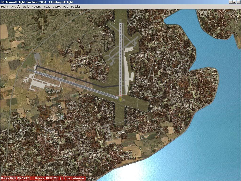
Maybe I AM crazy, but could someone take 3 or 4 screenshots of the general area... with an overhead/top down from about 15,000 feet for 1 of them?

I'd like to see both FS9 and FSX shots... So, I guess I am asking for 2 people to do this... if you have the time, of course.

((I got so whacked out in my disappontment that I stayed up most of the night re-landlcassing the area! Now I'm wondering if I really am just anal because, lately, almost every time I "start up FSX to just go flying" I seem to be starting SBuilderX nearly simultaneously!. :lol: ))
User avatar
KevinJarvis
Lieutenant Colonel
Lieutenant Colonel
Posts: 920
Joined: 10 Jun 2007, 19:13
Version: FS9
Location: Jacksonville, Illinois, USA, Earth
Contact:

Post by KevinJarvis »

Ford,
Here is my Eglin. Everything default.

KJ

Image
Kevin Jarvis

Image

Image
Ford Friendly
Lieutenant Colonel
Lieutenant Colonel
Posts: 823
Joined: 08 Jul 2007, 22:15
Version: FS9

Post by Ford Friendly »

Thanks Kevin.

Is that FS9 or FSX?

For comparison, here are a few shots.

The satellite reference pic I am using.
http://i195.photobucket.com/albums/z66/ ... 1222641254

My default view of the Eglin/Valparaiso area. I have both FSGenesis and Scenery Tech landclasses for FSX... This is the "best view" for this area that I can set up. Note, I have already reworked the afcad I was using to reflect the locations in the reference photo - about 90% complete.
http://i195.photobucket.com/albums/z66/ ... 1222641209

This is the current status after a night's work. Major roads repositioned/reflected accurately. An absent bridge created. Most of the forested areas nearest Eglin AFB are now properly reflected.
http://i195.photobucket.com/albums/z66/ ... 1222641296
User avatar
Jumpshot724
Major
Major
Posts: 767
Joined: 16 Feb 2008, 20:20
Version: FS9
Location: New York, USA

Post by Jumpshot724 »

((I got so whacked out in my disappontment that I stayed up most of the night re-landlcassing the area! Now I'm wondering if I really am just anal because, lately, almost every time I "start up FSX to just go flying" I seem to be starting SBuilderX nearly simultaneously!. ))
I'm the same way with scenery. Before I never used to care and would just "make do" with the default scenery, but now I have almost every single scenery installed for as many of the airports as I can for the VA I fly for. If I have a flight to do and I've never been there in FS before, the first thing I do is go on AVSIM and Flightsim.com to find a good scenery :D
-Joe W.

"I love the smell of jetfuel in the morning....smells like VICTORY!!"

Image
User avatar
mr.bean
Lieutenant Colonel
Lieutenant Colonel
Posts: 807
Joined: 26 Jul 2007, 18:40
Version: FS9

Post by mr.bean »

KevinJarvis wrote:Ford,
Here is my Eglin. Everything default.

KJ

Image

That's not Eglin. That's Duke. I know becuase I seen sat images of Eglin, and Duke before. Duke is sat airfield.
evvtsa
Second Lieutenant
Second Lieutenant
Posts: 24
Joined: 06 Dec 2006, 15:16
Version: FS9
Location: Indiana

Post by evvtsa »

Image

Hope this helps,
Bill
Ford Friendly
Lieutenant Colonel
Lieutenant Colonel
Posts: 823
Joined: 08 Jul 2007, 22:15
Version: FS9

Post by Ford Friendly »

Thanks Bill. If that's FSX, it confirms that it's not something with my default setup that makes this look so wrong compared to the satellite image.

If it's an FS9 image, then, the problem in both FS versions is a carry over/or incorrect resampling of the demographic datasets.

So much for trusting anything landclass-wise in MSFS in the future for me.
evvtsa
Second Lieutenant
Second Lieutenant
Posts: 24
Joined: 06 Dec 2006, 15:16
Version: FS9
Location: Indiana

Post by evvtsa »

Ford,
The screenshot is from a stock FS9. I had Ultimate Terrain on a previous install of FS9 and had a little performance issue so I decided to remove it. I know there is an option on Ultimate Terrain that updates the landclass to make it realistic. If someone has Ultimate Terrain installed you might want to get a screen shot from them.
Ford Friendly
Lieutenant Colonel
Lieutenant Colonel
Posts: 823
Joined: 08 Jul 2007, 22:15
Version: FS9

Post by Ford Friendly »

Shows what being old can do to one's mind. I'd forgotten that I also have Ultimate Terrain USA for FSX.

Switching between the three landclass packages while in the Eglin/Valparaiso area doesn't seem to significantly affect the landclassing. So, I've concluded that, at least in this area, the add-ons were a waste of money for what I want now - a realistic landclass for a small but significant area.

My scenery design thread asking for help identifying the name of a specific Eglin Bombing Range results from the same problem - totally inaccurate landclassing in a specific area.

In general, the addons make flying better than the default FSX, but as with the stock airports, a lot is left to be desired.

Sigh.

Thanks again, Bill.
User avatar
KevinJarvis
Lieutenant Colonel
Lieutenant Colonel
Posts: 920
Joined: 10 Jun 2007, 19:13
Version: FS9
Location: Jacksonville, Illinois, USA, Earth
Contact:

Post by KevinJarvis »

mr.bean wrote:
KevinJarvis wrote:Ford,
Here is my Eglin. Everything default.

KJ

Image

That's not Eglin. That's Duke. I know becuase I seen sat images of Eglin, and Duke before. Duke is sat airfield.
Yeah..don't know how that happened. :oops:
I think I got lost while warping to altitude...LOL.
Kevin Jarvis

Image

Image
Post Reply