custom with elevation on 191m(on default is around 60m) and nothing...and I add mesh for Bulgaria and still nothing...
I will check on another forum and, when I fix it I will notify you.
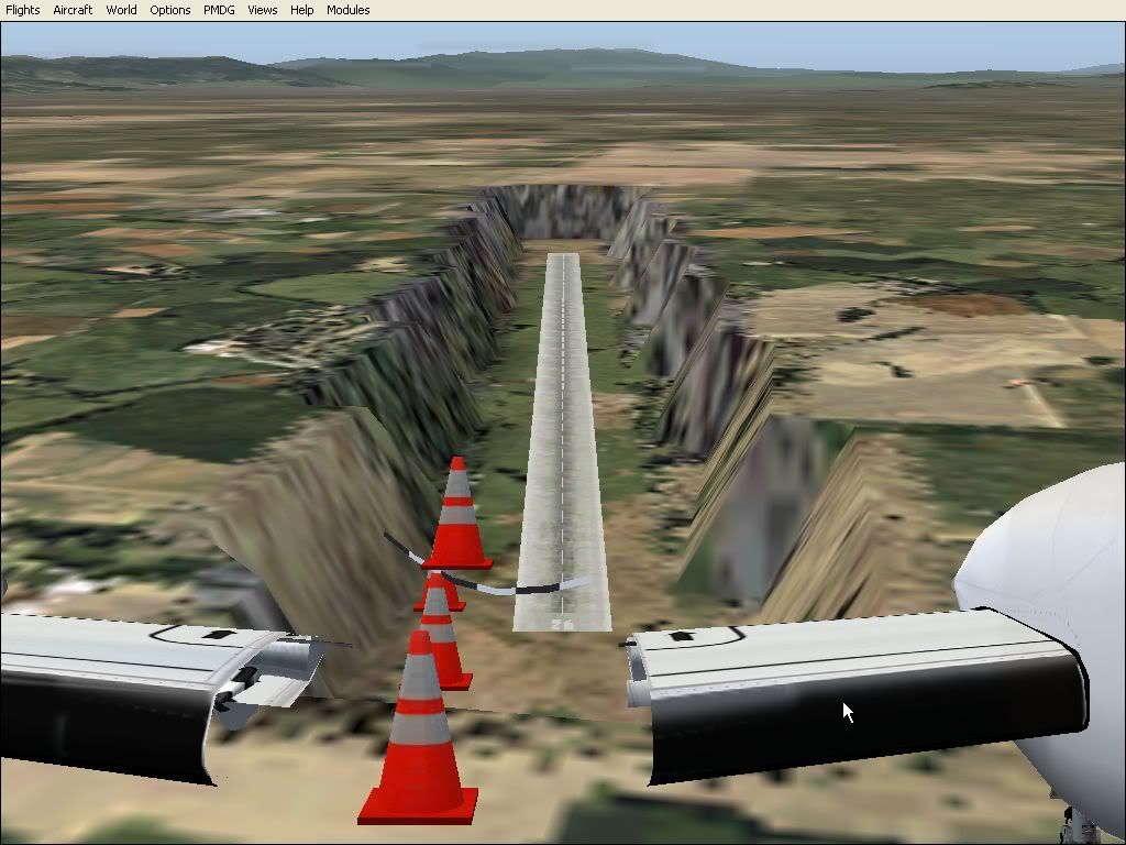
It's not an AFCAD problem as you can see the runway is laying on the ground.
If the elevation of the AFCAD is raised, the runway will be floating in the air.
It's a problem with the elevation of the mesh used for that area.
A quick look at the info I found is that Graf Ignatievo is supposed to 190' ASL.
However, Graf Ignatievo South is supposed to be 623' and Plovdiv at 597'. This leads me to conclude that either there is one hell of a valley that Graf Ignatievo is at the bottom of and no mesh has this feature, or the 190' is a massive mistake and it should be 190m (623').
As its an old Eastern Bloc military air base that nobody lands at it could that a massive assumption on the height was made by somebody and it has been propagated around the internet. I think that what we need is either local knowledge or somebody to get their hands on USAF airfirld docs for the place, as its a Bulgarian-American Joint Military Facility.
I tried to place it at 190m and got it floating above that runway sized trench. I would say that its to do with the default mesh system and you will probably need another scenery tool to fix this, as the airfield is not a default one.
Steve _______________________________________________________ Quid Si Coelum Ruat
Chelsea FC - World Champions _______________________________________________________
As I checked the ASL on Google Earth, I came to the conclusion that there doesn't exist any significant difference in the altitude and that there aren't any valleys. There is a flat terrain that surrounds the air base. Also, you can find many photos of Graf Ignatievo on the internet where you can clearly see that it is not in the valley.
I would just like to ask about the tool which I could use to fix this problem. Does anybody know?
Before you dismiss Jabbgl so quckly due to the "floating aircraft" comment in the readme/description...
First, remember that
1) airport boundaries usually incorporate flattens which are different than runway-specific/runway-created flattens
2) runways create flattens by their nature - and the flattens are not simply limited to the edge of the hard surface itself and
3) runway elevation and airport elevation are separate settings/data points - from each other AND from terrain mesh elevation settings/points.
Having said that, consider trying this:
Set runway length to 1 meter while leaving the width as it is. Restart FS. Is that valley still there in the same size and shape?
If so, I'd believe it's a terrain-mesh-caused valley - which includes default or addon. Terrain meshes are notorious for errors, unintended spikes, holes, etc.
If not, then I'd believe it's an afcad-elevation-caused valley because runways create flattens around them - or -
it could be a mismatch between elevation data .... including possible conflicts between default and addon terrain meshes, between airport elevation and runway elevation - or - between all of those.
This is where Jabbgl comes in. By adjusting the terrain mesh elevation and the afcad/runway elevation together, you can make/remove runway-related mounds/valleys for aesthetic or functional purposes. Together with Flattex, mentioned in the link from the post above, you'd be surprised at what you can do with a bit of ingenuity.
Fwiw, I don't dismiss unorthodox ideas or an unorthodox use of an application/program out of hand. Suggestions are usually based on experience and problem interpretation rather than misunderstanding the problem. I used narrow width "non-functional" runways and taxiways multiple times to create undulations in "grassy areas" at airports. That's the basis for mentioning Jabbgl.
And with that comment, good luck. I leave the thread except to hear if/when/how you solve the problem.
Why waste 'trons for a snappy signature when I can use this?
There is one drawback to using Jabbgl. There is no default airfield to amend the height of, so I think that this eliminates its usefulness. I was thinking more of creating an area flatten in Sbuilder to cover the area of the airfield.
Thank you all for trying i found all this programs BUT,
i found one Bulgarian sim forum and became member(We have a little bit simillar language enough to understand some words).There aro on IVAO Bulgaria sceneries for most of the Bulgarian airports and bases.Who wants may try ,it's on English.So I give up from making AFCAD